GOTLAND ARCHAEOLOGICAL
FIELD SCHOOL
PAVIKEN, A VENDEL AND VIKING AGE HARBOUR AND TRADING SITE
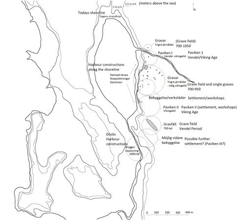
Paviken is a small ocean lagoon on the west coast of Gotland and is today connected to the sea by a small outlet. It gets it's water supply from the inland wetlands and is today a nature reserve with a rich bird and plant life. When walking on the east part of the site that slopes down to the water from the inland agricultural land you see a calm landscape with cows and sheep grazing, the still Paviken water and on the horizon the Baltic Sea. The picture was a bit different during the Vendel and Viking age.
Paviken is situated in the north side of Västergarn parish, one of the smallest parishes on the island of Gotland. Västergarn has an interesting early medieval history and it is with the discussions around Västergarn that Paviken is mentioned in the earliest sources.
In 1924, Adolf Schuck writes about the Gotlandic coast and in his discussion of harbour activities in Västergarn he mentions Paviken. The site had in folklore traditions been Västergarns inner harbour, protected from the weather and sea. According to the parish people, finds of shipwrecks and other wooden constructions had been made in the wetland. Ten years later the famous Swedish archaeologist Birger Nerman, who was then investigating the Viking Age harbour Grobina in Latvia, theorized that the eastern part of Paviken was the original harbour of Västergarn. He based his conclusions on stray finds and visible remains from the area.
The first archaeological investigations at the site occured during the 1960's. The site underwent phosphate mapping in 1961 by Hans Hansson. This showed two areas of interest named Paviken I and Paviken II. Test pits were made in both areas in 1961 and in Paviken I he found a rich, 30 centimeters thick, cultural layer, a large amount of boat rivets and three find materials that he could date.
These finds consisted of a silver armring, a Thor's hammer and a bronze pendant. After these finds he dated the site to the 10th and 11th century. In Paviken II he found animal bones, a smaller cultural layer and heavily rusted iron artefacts.Paviken II was there after neglected and focus was turned to Paviken I. Paviken II, however, was the largest site in regards to the phosphate mappings.
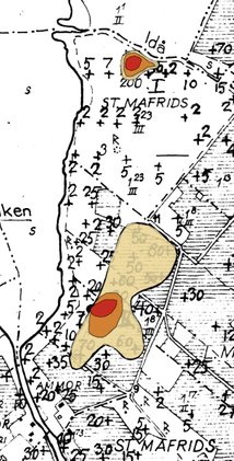
The results from the phosphate mapping carried out by Hans Hansson in 1961. The two areas of high phosphate values are showed by the coloured areas. Paviken I is the northern site and Paviken II is the southern site.
In the late 1960's, Per Lundström and Jan Peder Lamm began excavating Paviken I. They spent 6 years at the site, excavating around 1000 square meters and found over 10,000 single find posts. They concentrated on the main area of activity at Paviken I which they had singled out after another phosphate mapping. They also made search trenches to the south east and south west to delimit the site archaeologically.
These investigations resulted in a short book where Per Lundström presented the results from Paviken I. No official report presenting the archaeological analysis, trench or construction plans, sections drawings finds list, photographs or find descriptions and categories were made.
In 1993 archaeologists return to the site. Dan Carlsson with a team of students spent three seasons investigating areas outside of Paviken I to get a better understanding of the size, structure and function of the site and its different components. These investigations included the southern grave field belonging to Paviken I, another grave field south of Paviken II, a house remain in between Paviken I and II and harbour constructions in the outlet of Paviken.
In 2013 Gotland Archaeological Field School started the Paviken Research Project with the intention to piece out the earlier excavations at the site and build a larger, more complete, picture over the entire eastern shore of Paviken.
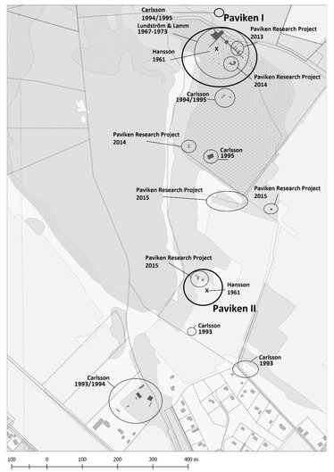
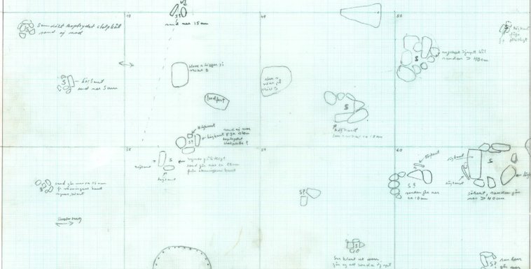
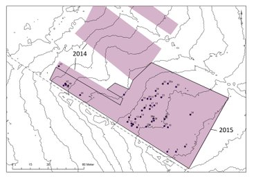
Map over the different excavations at the eastern part of Paviken.
The investigations started at Paviken I with a purpouse of investigating and document the cultural layer that had been excavated in the 1960's. The excavation entailed only 14 students and trenches were placed in an area that in the 60's excavation indicated workshops. In 2014 we were in the search for further evidence of settlement at the site. With the intention to find evidence of year-round houses we found the opposite. An area that was also used for crafting and contained weak evidence of structural houses.
After this, we continued in 2014 by starting the journey down towards Paviken II. in the 90's, around 70 meters to the west from Dan Carlsson's investigated house remains, there was another house remain just at the Viking Age beach. This house was partly excavated in 2014. The 2015 investigations were focused towards Paviken II, a site that been neglected archaeologically for almost 50 years.
There is more information about the different excavations, results and interpretations below. Paviken is now no longer a focus for excavations but instead for research. There is a large amount of material that needs to be compiled and a full publication is to be expected in the following years.
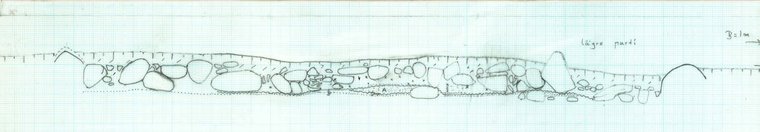
Excavations 1967-1973
Excavations began in the late 1960's by Per Lundström and Jan Peder Lamm. During the 6 years of investigations they excavated around 1000 square meters at Paviken I and recorded over 10 000 finds. Among these finds were glass beads, amber objects, garnet pieces silver coins, jewelry and bullion, iron tools, bronze jewelry, bone and antler objects such as combs and dices together with animal bones, ceramics, stone artefacts such as net sinks and more. The excavations were carried out with 2x2 meter squares that were shoveled through the first cultural layer and the deposits water sifted. After this layer a second layer with sand was noted. This was the "floor" area and also where most of the constructions were found. The sand layer was not excavated fully and neither were the constructions. They were left intact for future investigations, covered with black tarp and the trenches filled up.
The excavations led to the first harbour and trading site on Gotland from the Viking Age to undergo large scale excavations and it has dominated the debate regarding Gotland's role in the Viking Age trade ever since. It has never been fully published though; Per Lundström wrote a short book presenting the results but without a find list or any analyses regarding the finds, no trench plans or construction descriptions. He very much intended to do so but didn't get the chance before he passed away.
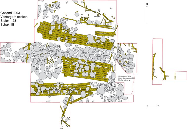
Reconstructed and merged plans over the main excavation area at Paviken I.
Construction plan from 1968 over the Paviken I excavation.


TRADE AND CRAFTS AT THE SITE
Lundström and Lamm uncovered finds that pointed towards the fact that this was not only a harbour but that the people who used the site had also been engaged in trading and crafting. Weights and bullion silver were uncovered in the main area of the site which suggested to them that an exchange of commodities had taken place.
To support this hypothesis, they also relied on the evidence of crafting at the site. Glass was found as raw material, as manufacturing waste, half finished products and finished products in the form of glass beads. The same was found for amber with raw material, broken or discarded artefacts and finished products as beads and a Thors hammer. Garnet, a semi-precious stone, was also found, but only as raw material. The amber, garnet and glass were imported to Gotland and strengthen Paviken's role as a trading site.
Ingots for silver or bronze together with bronze bullion, slag and finished pieces provided the evidence for metal working as well as glass and semi-precious stone working. With this, there are also signs of bone and antler crafts, again, antler not being local to Gotland had to be imported. The main thing missing from the site is the manufacturing constructions; no big furnaces or smithys have been found at Paviken I which in general has a weak settlement pattern with no distinguished houses.
EVERYDAY LIFE - cooking, fishing and personal belongings
A big part of the find material discovered in the early excavations at Paviken reflect the everyday activities at the site that were not a direct result from trading or crafting. For example, animal bones for food consumption is one of the biggest find categories at the site.
An osteological analysis of the animal bones showed that the biggest category (65%) of animals used at the site was cattle. This differs from other harbour sites where either domestic swine or an even distribution between cattle, sheep/goat and domestic swine occured. It also differs from a town perspective where domestic swine is most common and from a farm perspective where sheep/goat is more dominant. Why is Paviken dominated by cattle? This question doesnt have an answer at the moment. It has been suggested that this is an evidence for the selling of cattle and further Pavikens status as a big trading site. It may also be a result of the nearby farms that would have provided Paviken with food being focused on cattle, or it is the result of bias archaeological research. With only 3% of the animal bones analysed and a lack of other similar osteological investigations at different sites on the island we clearly need more research to be able to conclude anything around the animal husbandry and it's meaning at Paviken.
Constructions such as post holes for structures and hearths are also evident at the site. There is, however, no telling if these are products of crafting, such as workshops, or living quarters. In other trading sites, such as Kaupang in Norway, crafting, trading and living occured on the same house or plot. There are no evidence of plots at Paviken, or of traditional houses. This has been the reason for Paviken's interpretation as a seasonal site and the general outlay of activity and structural postholes are distributed in a way that is more similar to a fishing hamlet.
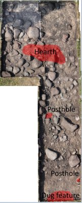
Storage can be showed in the ceramics found at the sites, these ceramics show a slavic origin to the east and the people at Paviken sure had something to lock away since keys are quite common at Paviken I. Fishing has been one of the activities at Paviken and is shown through the net sinks and leisters. Personal belongings are a tricky find category at sites like Paviken. One can argue that jewelry, beads and tools are personal belongings. This will have to be theorized however. Beads and jewelry can be products meant for sale as well as being used as personal dress ornaments or even raw material for production or re-use. For the finds usually categorised as personal belongings, all of the above meanings are probably more likely.
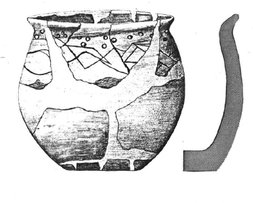
Ceramic vessel reconstruction.
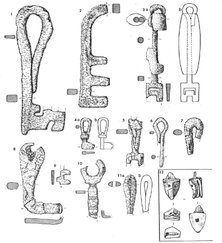
Keys found at Paviken I.
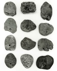
Net sinks.
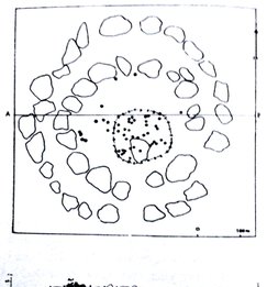
INTRASITE BURIALS
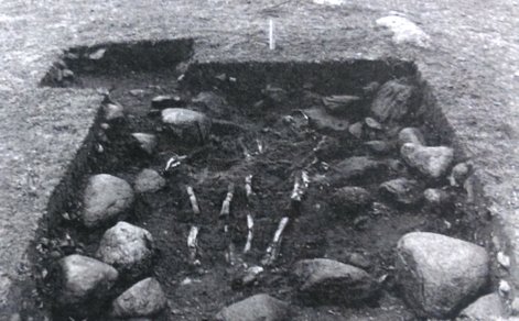
In the center of the Paviken I site there is a round stone setting. This stone setting included an inhumation burial of a male seen in the picture to the right. There were also cremations in the grave. One of the cremations had been placed in an urn together with the skeletal remains. Others had been scattered in the grave without any noticable vessel containing them. The man had a grave good in the form of a ring brooch. Other finds from the grave such as iron fragments, antler objects, amber and glass cannot be determined to belong to one individual.
The custom of secondary burials in the form of cremations is not uncommon in the Vendel and Viking Age Gotland. This may indicate lineage, worship of ancestors or continuity in the usage of the grave as a marker in the landscape, or in this case in the usage of the trading site. This man may be one of the founders of the site or his grave has been used to anchor a specific group or family to the site.
At the waterfront of the Paviken I settlement there is also another burial. Dug into a depression made for dragging boats ashore lay another inhumation, buried without any structure or noticable grave goods and placed on its stomach. The grave is poorly documented and no photographs have yet been found.
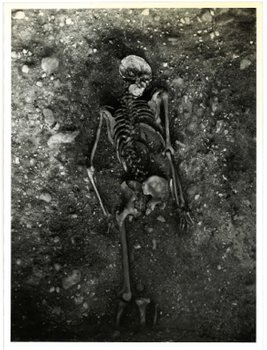
Stone setting inhumation in the center of the Paviken I site.
Section drawing of the stone setting.
Excavations 1993-1995
After a gap of over 25 years archaeologists finally returned to Paviken. Focus was shifted from excavating a single large area of the settlement site to investigating smaller parts of the area to fill in some of the missing parts of the research. This was done to drive the discussion around Paviken further and viewing the area's landscape as a whole. This may have its roots in theoretical changes in archaeology that brought on a more landscape view of particular sites, something that was missing in older research. The excavations were led by Dan Carlsson and executed with a team of students from Gotland University.
Above, the excavated grave in the north side of Paviken I and one of the excavated graves from the grave field on the south side of Paviken I.
GRAVES AND GRAVEFIELDS
Paviken's eastern shore is littered with remains of Iron Age graves. They occur from the nort side of Paviken I to the south side of Paviken II. In 1994 and 1995 excavations were done on one of the graves in the north, several burials from the grave field on the south side of Paviken I and on the south side of Paviken II, towards the end of what consitutes the entire Paviken area.
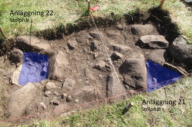
The grave in the north had two border chains and contained the cremated remains of an adult individual. There were several finds of nails and rivets in the burnt bone layer together with a presumed ring brooch. The grave is dated to Vendel/Early Viking Age and is part of a bigger grave field that runs in an east-west direction along the north side of the river that fills Paviken with water from inland.
The second grave field that was excavated on the south side of Paviken I showed burials in stone settings with cremations and inhumations. All of the burials had burnt bone and grave goods. They are dated to the Vendel/Viking Period. In one of the graves a dog and a horse were interpreted to be part of the grave goods.
On the south side of Paviken II, towards the modern day buildings, there was another gravefield that had been noted by Birger Nerman in the 1930's. The graves here differ from other graves in the area because they are not covered by a stone packing. Instead, they are dug graves, not visable above ground. This has led the probable destruction of a lot of graves due to modern history's agricultural work. Loose finds connected to the grave field have been reported since the 19th century and the original size of the area can be determined. Carlsson theorizes that the area had originally consisted of hunderds of graves.
Double burial at the grave field on the south side of Paviken II. Note that the grave would not be visible above ground but only by a slight depression caused by the dug feature in the center of the grave.
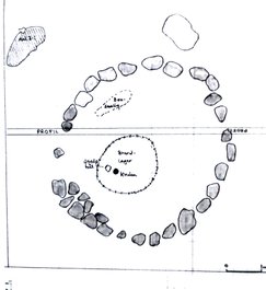
THE HOUSE FOUNDATION
There had been little interest outside Paviken I since Hansson discovered the site in 1961. The area had been noted as an activity area during the Iron Age but excavations had been limited to the cultural layer at Paviken I. In 1995, Dan Carlsson and his students investigated a house remain on the eastern shore of Paviken, between Paviken I and Paviken II.
Originally, the house looked as if would be older than Viking Age due to the stone wall construction of it. After excavation it was concluded, however, that the house was a Viking Age structure. Inside the house they found burnt and unburnt animal bones, iron rivets and nails, part of a scale, lead weights, glass, a sandstone mold for making crosses or Thor's hammers, two fragments of Arabic silver coins together with smaller unidentified iron artefacts.
The animal bones were dispursed in an uncommon way; the burnt bones were highly fragmented and found inside the house while the larger unburnt bones were mainly found outside. The highly fragmented burnt bone was something that we later came across in the 2013-2015 excavations and has been preliminary interpreted as part of the production at the site. They had no hearth and were not interpreted as part of a living house but rather a workshop or storage house connected to the activities at Paviken.
The distribution of burnt (black circle) and unburnt (lines within a circle) animal bones in the house foundation.
DOCKS IN THE OUTLET OF PAVIKEN
In the stream of water that connects Paviken directly to the Baltic Sea a set of docks were uncovered. The excavations took place in 1994 and 1995 by Dan Carlsson and a team of students. The area that was investigated was first phosphate mapped, which revealed an area of high values that today is partly covered with modern buildings. Other parts of the outlet had been investigated before and revealed similar features so the appearence of the docks was expected.
These were, however, very well preserved and could be dendrochronologically dated to the year 1008. They show the Viking Age activity that took place in and around Paviken was not only concentrated at Paviken I. The area where they were found was probably a water basin and destroyed by a spring flood. Several floods could be seen in stratigraphy as sandlayers in between the silt depositions.
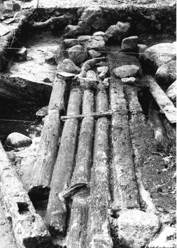
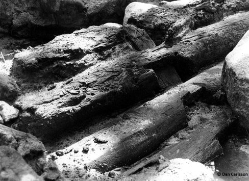
The docks during excavation. The logs were well preserved and could be dated to 1008.
Paviken Research Project 2013-2015
Trench plan over the docks.
It is clear that the harbour and manufacturing site at Paviken was crucial in the older history of Västergarn. However, the full and exact nature of the role that Paviken played in history remains unclear. Gotland Archaeological Field School carried out complimentary investigations at Paviken during a three-year field project between 2013 and 2015, followed by results analysis and interpretation in 2016. The aim of the project is to better understand the function and development of the site and how it fit into the surrounding landscape, not least the site’s connection to what later became Västergarn. It is necessary to understand the functional correlation between the different settlement areas as well as the different groups of graves on the eastern shore of Paviken, spread out over an area of approximately 400 x 1,000 metres. A further aim is to understand the earliest as well as the latest occupation at the site and thus to understand the time frame and connection to archaeological evidence in Västergarn and the Västergarn waterway. In addition to these issues of time and space, we also need to understand the role Paviken played in terms of manufacture and long distance trade. We are now starting the year for preparing publications and analysing the site.
PAVIKEN I - 2013
The excavations started in 2013 by investigating an area adjacent to Lundström and Lamms old search trench towards the east. The trenches meant to investigate the cultural layer, the stratigraphy and the condition of Lundström and Lamms old trench with the layer B (sand layer) still intact under a cover of black tarp.
The cultural layer consisted of dark, sand mixed soil where most of the finds were located. Underneath we uncovered layer B that consisted of sand, but also of natural clay and gravel mixed sand. Lundströms field notes also fit this description and we had a clear understanding of the stratigraphy of the settlement site. We excavated 8 square meters of Lundströms old trenches to investigate the condition of layer B. The tarp was intact when we opened the trenches and in them we found the abandoned constructions underneath. We also sifted the backfill from Lundström and Lamm and found a few artefacts that they had missed, for example a small gold bar.
We uncovered a large number of artefacts and constructions that confirmed that the area was probably used for crafting. Glass and glass beads were abundant in the three trenches we excavated. The raw material consisted of opaque glass tessarea, a find that Lundström interpreted had an origin in Italy. Together with beads we also found 325 pieces of unpolished garnet and amber, both raw material, half finished and finished beads.
With this we also found scrap pieces of iron, iron artefacs such as knives, rivets, nails and a wedge. Besides the finds, we uncovered a large hearth (2x1 meter) and a clay platform which could have been used in the bead production, as well as dug features and postholes. No buildings could be seen in the features of the excavated area.
During this season we found further evidence that dragged the limit of large scale activity in Paviken I further to the east. We concluded that the area was purely for crafting and living. We found one Arabic silver coin and two smaller lead weights. This could mean that trading occured on the site but it's more likely that the weights were used in the production process. We also started mapping the sorrounding area for the next season of excavating. We noted a small hill further to the south. This was a site that had high phosphates but had not been investigated before.
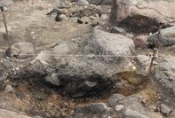
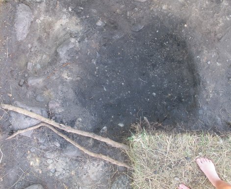
On the right, trench three in the 2013 excavation. At the top of the picture the big hearth can be seen.
Above, a section of the hearth.
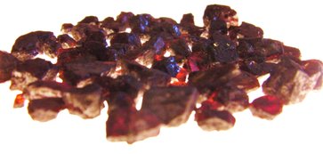
Garnet found during the 2013 excavation


Glass beads from the 2013 excavation at Paviken I. Photos by Alan Burchell.
PAVIKEN I AND A HOUSE FOUNDATION ON THE BEACH - 2014
In the beginning of the season in 2014, we excavated the area noted the year before. Directly under the turf we noted that the surface on the trench was filled with stones around 20-30 centimeters in diameter. This set the tone for the excavation of the surface that went slowly because the difficulty with excavating around the stones. The stone packing represented the work area for the activities that took place in the area and were probably found natural at the site and were constructed in roughly two layers. This probably meant a redustribution of the naturally occuring stones to create a working surface at the site. We set out with a hypothesis of this being the place for a more structured settlement. This turned out not to be the case and the archaeology reminded us very much of the situation the year before. The differences in the two areas were represented in the find material. Even though the layout of the constructions in this area had a smaller cultural layer, concentrations of highly fragmented burnt animal bone and was missing the amount of garnet, amber and glass that we found in 2013. It was more characterized by bronze and scrap pieces of iron. A few small fragments of silver were found but generally the find materials were scarcer than the year before.


Trench plans over the different feature or constructions at the 2014 excavation.
Plan over the excavation of the house foundation excavated in 2014.
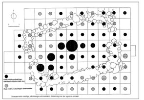
Following the phosphate mapping of the site and the distribution of different find categories a rough spatial structure of the site could be determined. The highest distribution of silver, and weights can be found at the western part of the Paviken I site (number 1 in the map). This area was the site for some of the highest phosphate readings and also where Lundström and Lamm concentrated their excavation in the 60's and 70's. Laying just at the waterfront of Paviken and the juncture to the river flowing from inland, this is probably the area where most of the trading and exchange took place. If we follow the site to the east we encounter an area enclosed by what is today just a single row of stones, probably a more distinct stone wall during the time of occupation. Inside this enclosed area (number 2 in the map) we have a find distribution of fine crafting and raw material. The grave that was excavated by Lundström and Lamm is situated in the opening towards the river Idån and the main trading area. Moving south from this, we have the last high phosphate readings and the site for excavation in 2014 (number 3 in the map). The area has some of the characteristics of the enclosed area but with a smaller cultural layer, less raw material such as garnet, beads, glass and amber, a few silver fragments and no evident signs of permanent living houses. The features such as hearths, refuse pits, postholes, the stone packing and the concentrations of highly fragmented burnt bone signifies a work area for manufacture and production in a more rough sense than the enclosed area.
This distribution of different find categories together with features, cultural layers and visible remains above ground shows a general layout of the site and its intra site functions. The spatial structure of this area shows a situation quite different from some of the larger trading sites during the Viking Age and the question is what this means in regards to the Gotlandic trading and Paviken's role in the Viking Age society. These are preliminary results from some of the analysis at Paviken I and further research are underway.
PAVIKEN II, AREAS BETWEEN PAVIKEN I AND III, THE GRAVEFIELD IN THE SOUTH - 2015
The most recent excavation at Paviken was done in 2015 and investigated the before neglected site of Paviken II found at the southern part of the eastern shore of Paviken. The site had lower phosphate values than Paviken I but spread over a larger area. It is also partly cultivated. We investigated both parts that were cultivated and parts that had not been affected by agriculture.
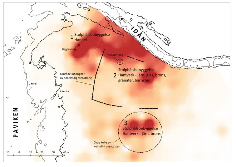
Map over the intrasite structure of Paviken I. The map is in Swedish but a description can be found below.
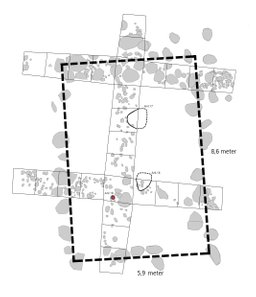
Moving on from Paviken I, the second part of the 2014 excavation was focused towards a house foundation in between Paviken I and II. The house is located around 70 meters west from the house excavated by Carlsson in the 90's and sits on a hight of 2,7 meters above the sea. This puts it right at the beach during the Viking Age and the house has its long side parallel to the water of Paviken.
The house had no distinct cultural layer but a thin horizon of gravel. Inside the house, there were two concentrations of highly fragmented burnt bone and a posthole. The post in the posthole was dated to the 8th century and makes the house contemporary with the activities at Paviken. Only a few small iron objects were found in the house. No hearth or unburnt animal bone was found that could indicate any type of living quarters.
Being situated right at the beach the house was probably used for either storing or just a temporary structure. Needless to say, the exact function of the house is still unclear due to the lack of arhcaeology inside it. It was possibly swiped clean before abandonment.
The trenches from the cultivated parts of Paviken II revealed a 20 centimeters thick plough layer with dark soil mixed with sand. The finds consisted of smaller rusted iron fragments, fragmented burnt and some unburnt bone together with one Viking Age bead.
Underneath the plough layer the bottom parts of dug features such as possible postholes and refuse pits were found. The features contained no finds except some burnt and unburnt animal bones. This showed that activity had taken place in the area but there was no surviving cultural layer to be found.
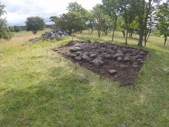
In the parts where agricultural activities had not taken place the intact cultural layer could be found. This consisted of a gravel horizon, 10 centimeters in thickness and containing finds of whet stones, glass beads, knifes, rivets and nails, small fragments of silver and a mould for silver bars. Some temporary hearths with the, now, common highly fragmented burnt animal bone and also some refuse pits with unburnt animal bones were found.
One large hearth (1x1,5 meters) was found (feature 23) near where most of the finds were concentrated. The hearth consisted of charcoal mixed soil and was dug into the natural clay layer.
The excavation was situated at 3,5 meters above the sea and concerned a beach zone with evidence of a barrier between sand and gravel mixed cultural layer. The gravel contained most of the finds outside the features and the features found where located within the sand part of the trenches. This may indicate refuse being placed on the beach as to keep working areas clean.


Construction 23, hearth, fully excavated.
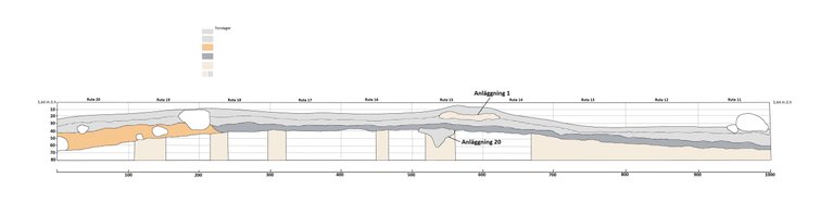
Section plan over trench three. In the left part of the plan the break between the sand and gravel part of the activity layer can be seen. The plan slopes to the right towards the shoreline.
Paviken II probably doesn't fill the same functions as Paviken I in regards to trading and living. The thin cultural layer and the lower phosphate values indicate a more sporadic or different kind of activity at the site. It does, however, show signs of manufacture and production with finds like the mould, silver fragments, the large hearth and highly fragmented burnt animal bones. Only a small part of Paviken II has yet been excavated and the interpretation of the site might differ with more archaeological research. With this said, the 2015 excavation took place at the only location within the site that had not been cultivated or where other natural and man made obstacles would make an excavation difficult or hard to interpret
Together with the excavations at Paviken II, the area between I and II was investigated with phosphate and metal detecting surveys. These surveys led to test pits being laid out in one of the fields in between the sites. These test pits showed no sign of any cultural layer but two shallow postholes where found in one of the pits together with some fragmented pieces of burnt bone.
A possible stone setting and burial was excavated at the eastern part of the Paviken area. This investigations showed that it was not a stone setting and was excluded from the interpretations of the site. The feature had some burnt bone and quartz finds and was situated next to a Bronze Age grave; it was interpreted as a Bronze Age feature but with an unclear function.
Shallow post holes from the test pits in the 2015 excavation.
The southern grave field that demarcated the Vendel and Viking Age activities at Paviken to the south had been investigated by Dan Carlsson in the 1990's. During 2015 we continued these investigations with a metal detecting survey of an area in a modern day agricultural field where the grave field was presumed to extend into.
The result from the metal detecting survey indicated a grave field from the Vendel period with dress ornaments typical for the period. With the typical Vendel Age grave material another find category was also found: Viking Age Coins and polyedric weights. This does not match the excavated graves from the grave field or the Paviken II find material. The metal detecting actually showed a higher concentration of coins and weights than in Paviken I. This indicates the possibility of another Viking Age trading site near the southern part of Paviken and at the beginning of the outlet to the Baltic Sea, as mentioned before the outlet has many traces of harbour structures. The area is today the site for modern summer houses and is therefore much disturbed.
The Bronze Age construction from the 2015 excavation.
Metal detecting survey over the southern grave field. The dispersion of finds are in line with the plough direction at the modern agricultural field.
With the above summarized excavations we can now start to build a complete picture over the Paviken area and the entire site during the Vendel and Viking periods. The evidence shows a spread out activity with concentrated areas for trading and manufacturing.
The area between Paviken I and II shows a sporadic or short term, small scale, activity connected with manufacture and production and the main area for activity still being Paviken I and the north part of the site. The two house foundations found during the 1990's excavations by Dan Carlsson and in 2014 together with the postholes from 2015 supports this thesis.
The entire site is too large to present in full here and is also not fully analysed or published. Following years will be spent at this task and the aggregated information presented here is meant as a general insight into the research history of the site. Further research into the indications of another trading cluster south of Paviken II would fill any questions around the function of the outlet part of the area, is it possible that we are dealing with yet another settlement at Paviken, a Paviken III?